Wednesday, January 04, 2006

Rio Grande River


The Rio Grande River drops 12,000 feet from source to mouth. As a snow-fed torrent, carver of canyons, desert streams, and a meandering coastal river. Along its banks and in its valley Indian civilizations developed and the white man made some of his first North American settlements. The Rio Grande River is an international boundary, and the picture shown was taken on the bridge crossing from country to country.

Cacti

Texas, because of its extensive area and climatic conditions favorable to the growth of cacti, contains over one hundred species, representing the widest assortment found in any state in the United States. Texas cacti are used for foods, for landscaping, and for commerical and private botanical collections. The climatic adaptability of cacti and their ease of culture make them useful in gardens and as shubbery; their unusual forms and multi-colored perennial flowers attract many collectors. The cacti shown above was photographed south of San Antonio.

Texarkana


Texarkana is a city of two states. Vistors may stand straddling the line with one foot in Texas and the other foot in Arkansas. State Line Avenue divides the city.

South Padre Island


My bike tire speeding down the beach. Winter temperatures of 80 plus degrees are not unlikely. It is also the "off-season" so it's nice and quiet.

The Sandhills of Monahan


Consists of 3,840 acres of sand dunes in Ward and Winkler County very near the New Mexico border.

Tuesday, January 03, 2006

The Trinity River

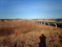
The Trinity River is the longest river having its entire course within the state. Though smaller than several other Texas river basins, the Trinity has been recognized during the first half of the twentieth century as the one with the largest population and the greatest amount of industrial development. The annual flow of the stream is highly irregular because much of the watershed’s rainfall is so concentrated causing several disastrous floods before a 1944 flood control act provided relief.

The San Antonio River

The San Antonio River rises just north of the city of San Antonio and flows southeast for approximately 180 miles. The river has served many functions, furnishing drinking water and water for irrigation and for power to turn the wheels of mills, foundries, and tanneries, but in recent times it has been most significant for its beauty. Conversion of the river into a thoroughfare by building walks from all principal downtown streets and deepening the stream to make it navigable for small river craft was a part of the WPA grant in 1939. It also included the construction of river-edge walks, landscaping, building of electrical fountains, and the creation of an outdoor theater equipped with water curtains.

The Sabine River

The Sabine River extends for approximately 360 miles from mouth to source and flows through a forested sandy land territory adaptable to the conservation of runoff and is fed by many flowing tributaries and small springs. In the early days of the Republic this river furnished transportation facilities for lumber and cotton from the southeastern portion of the state (the Sabine splits Louisiana and Texas towards the river’s mouth). Great logs cut from the pine forest were lashed together, making rafts which were then floated downstream into the Gulf of Mexico.

The Guadalupe River

The Guadalupe River flows for approximately 250 miles and its drainage area is some 6,000 square miles. A uniformity of tributary springs makes the stream of value for water power, dozens of damns and power plants are in operation along the river. It is also used for municipal water supplies and for irrigation purposes.

The Brazos River

The Brazos River is the longest river in Texas with an estimated length of some 840 miles. Cotton and sugar plantations established along the Brazos in the pre-Civil War days were show places of Texas and the homes of some of the wealthiest men in the state.